

The Concept of Strategic Depth
Strategic depth is that space between the frontlines or borders of a nation and its centers of gravity, essentially its industrial hubs or important population centers. In recent times this definition has been given a political dimension wherein installation of favourable governments in the immediate neighbourhood also facilitates strategic depth. For instance, Pakistan’s obsession with strategic depth is premised on its perceived threat from India and seeks to control the regime and space in Afghanistan to achieve this depth. A Pakistani military officer best describes Pakistan’s need for strategic depth arguing that “the Afghan territory could provide a strategic depth to Pakistan in case of an Indian onslaught, where, at the time of need Pakistan Army can withdraw, reorganise, and after gaining their balance, can carry out counter attacks in order to evict the enemy from the captured areas. The factors of terrain, demography and sustainability in this regard are best suited for Pakistan, provided the political government in Afghanistan is friendly and supportive”.1 In sum, strategic depth is a factor of geography, demography, political and military control of an area beyond its immediate borders.
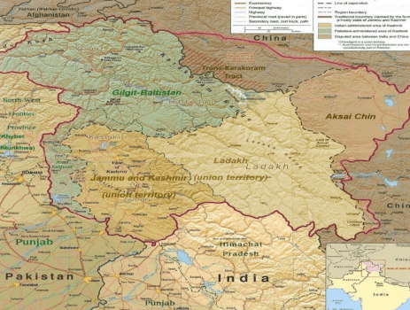
Hemmed in geographically by Pakistan & China, recent developments in Eastern Ladakh especially the incursions by PLA in DBO (2013), Chumar (2014) and Depsang- Pangong-tso (2020- to date), is evidence of China’s shifting stance on the status of the LAC. The ongoing standoff has not only put to question decades of peace & tranquillity on the LAC but forced India to revisit her security calculus in this region. This has necessitated redeployment of the Indian defence forces, the border troops as well as a concerted effort at giving impetus to infrastructure development, roads, forward bases, airfields and logistic installations. Chinese interests focus on the CPEC running through Gilgit-Baltistan, and to secure this corridor, she would like to integrate the Trans-Karakoram Tract with Aksai-Chin by forcing India to extricate from the Nubra-ChipChap valleys. A two front threat best manifests in this area of Ladakh.
A Case for Strategic Depth for India
The similarity between Afghanistan and Gilgit-Baltistan is striking. The Durand Line was created by the British to impose a buffer state between an expanding Tsarist Russia and the British empires. In the process it divided the Pashtuns on either side of the Durand Line. Successive governments in Afghanistan have refused to recognise the Durand Line and it continues to be a simmering faultline in Pakistan-Afghan relations particularly in the face of rising Pashtun nationalism. Gilgit-Baltistan too was treacherously captured by Pakistan despite the “Instrument of Accession” signed by the Maharaja of J&K in October 1947 to accede to India. For centuries these communities on either side of the Line of Control (LC) have lived together, whether under Tibetan, Mughal, Sikh or British empires. Today, the LC divides the people of Gilgit-Baltistan with Ladakh, and an uneasy calm prevails even though the LC has witnessed wars and artillery duels for decades. There is growing discontent in Gilgit-Baltistan towards Islamabad’s step brotherly treatment and the unfair division of revenue from the CPEC to GB amidst reports of rising GB nationalism. Politically, Gilgit-Baltistan is one of the most under developed regions of Pakistan with the people denied basic rights and needs while their cousins across the LC in Kargil-Ladakh have prospered in a free, secular and democratic society. The regions independent social, cultural and political entity is essential and must be supported by India.
India must work towards opening trade routes, facilitate people to people contacts as well as build cultural, educational & religious ties with the people of Gilgit-Baltistan. More importantly, like minded nations that have considerable influence in the populations in these areas must be encouraged to reach out to support these communities. Militarily, the strategic depth afforded by Gilgit- Baltistan extending from the area of Astore to Dansam along the LC and upto Skardu in depth (essentially areas contiguous to LC) would provide India the necessary elbow space and strategic depth to defend the Nubra-Chipchap valleys as also widen the pincers of any collusive plans between the two adversaries. While not easily done, the effort will be considerable in terms men & material. It will require persistence, time and resources to build a favourable narrative before undertaking any military option. A favourable populace in Gilgit-Baltistan, for instance, will energise the prospects of a pan- Dardic movement to confront Chinese hegemony in the region. For India, strategic depth in Gilgit-Baltistan provides a wider support base to counter an aggressive and expanding China. It will put pressure on China to pay heed to India’s concerns in the disputed area of the erstwhile state of J&K and ultimately pave the way for a settlement of the vexed J&K problem.
The Geography & Demography in NE Ladakh
The Union Territory of Ladakh (UT), formerly part of the erstwhile state of J&K, comprises of the vast area of Gilgit – Baltistan (GB) as well as the Aksai-Chin. Post 1947, GB was an autonomous region of Pakistan and governed from Islamabad. In 2015, Pakistan decided to convert Gilgit-Baltistan into a fifth province, held elections and instituted a Legislative Assembly but stayed short of giving GB full autonomy. Islamabad continues to hold powers to overrule any legislation in the Legislative assembly, a cause of dissent & denial of self-rule to the people of this region. Gilgit-Baltistan covers an area of over 72,971 sq kms and has a population of 1.8 mn, almost entirely Muslim. It has a chequered history of sectarian clashes between Sunni-Shia sects with the Ismailis and Nurbakshis as the other prevalent sects. The language, dress, culture and food habits closely connect to the Kargil-Dras region of Ladakh. In 1963, Pakistan conceded 5180 sq kms of the Trans-Karakoram Tract to China, and in 1984, India occupied the Saltoro Ridge in the Siachen Glacier, altering the strategic significance of the area. This area which includes Nubra & Chip-Chap valleys which have become extremely sensitive to India being encircled by Pakistan to its West & China to its North & East. (See map). The total distance from Saltoro Ridge (west extremity) to Daulat Beg Oldie (East extremity) is barely 80-100 kms separated by massifs of the Karakoram range. The Siachen Glacier is the gateway to Leh, the capital of Ladakh over the Khardungla Pass and cannot be compromised. Aside from this, the North-South aligned Saltoro Ridge is the only major terrain feature that prevents the Aksai-Chin from connecting to the Shaksgam Valley in the Trans-Karakoram tract. This narrow strip has the potential to become a major flashpoint in a collusive option by both adversaries.
Endnotes
- Lt Col Khalid Masood Khan (retd), “The Strategic Depth Concept”, The Nation, 16 October 2015.
Author
Maj Gen Mandip Singh, SM, VSM (Retd)
Maj Gen Mandip Singh, SM, VSM (Retd) is presently a Distinguished Fellow at United Service Institution of India (USI), a leading Military think tank based in New Delhi. He is also a Senior Fellow at Manohar Parrikar Institute of Defence Studies & Analyses, where he previously headed the East Asia Centre. Maj. Gen. Singh is also a Visiting Fellow at Mercator Institute of China Studies, Berlin, Germany and Visiting Faculty at ITBP Academy Mussoorie, BSF Academy, Tekanpur, DSSC Wellington, Naval War College (Goa), Air War College (Hyderabad), Panjab University and Allahabad University.